

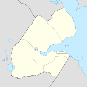
Galafi (Arabic: غالافي), also known as Gâlâfi, is a village in Djibouti. Galafi is the official border crossing from Djibouti into Ethiopia. Situated on the border with Ethiopia, it is in the north west of Dikhil. It lies on the National Highway 1. It is located some 218 km (135 mi) west of the national capital, Djibouti City. Nearby towns and villages include Yoboki (40 km), Dikhil (98 km), Semera (114 km), Bure (157 km) and Elidar (70 km).
YouTube Encyclopedic
-
1/1Views:2 379
-
Top 10 Largest Cities or Towns of Djibouti
Transcription
History
Since 1975, an all-weather road combines Galafi with Djibouti City and neighboring Ethiopia and Eritrea. This road, part of the trade between Ethiopia and Djibouti, is handled, but it plays a minor role compared with the railway link Addis Ababa and Djibouti City. In 1978 she came briefly to the more important in the rail route was suspended due to the Ogaden War. On 27 May 1991, 30,000 men from the Ethiopian army forcing the way to the West boundary to Galafi during the Ethiopian Civil War.
Climate
| Climate data for Galafi | |||||||||||||
|---|---|---|---|---|---|---|---|---|---|---|---|---|---|
| Month | Jan | Feb | Mar | Apr | May | Jun | Jul | Aug | Sep | Oct | Nov | Dec | Year |
| Mean daily maximum °C (°F) | 30.1 (86.2) |
30.5 (86.9) |
32.5 (90.5) |
34.6 (94.3) |
37.6 (99.7) |
40.9 (105.6) |
40.2 (104.4) |
38.8 (101.8) |
37.6 (99.7) |
34.9 (94.8) |
32.1 (89.8) |
30.4 (86.7) |
35.0 (95.0) |
| Mean daily minimum °C (°F) | 20.0 (68.0) |
21.9 (71.4) |
23.2 (73.8) |
24.9 (76.8) |
27.1 (80.8) |
29.4 (84.9) |
28.0 (82.4) |
27.5 (81.5) |
28.2 (82.8) |
24.7 (76.5) |
22.2 (72.0) |
21.0 (69.8) |
24.8 (76.7) |
| Average precipitation mm (inches) | 5 (0.2) |
6 (0.2) |
8 (0.3) |
9 (0.4) |
5 (0.2) |
2 (0.1) |
26 (1.0) |
38 (1.5) |
16 (0.6) |
4 (0.2) |
7 (0.3) |
3 (0.1) |
129 (5.1) |
| Source: Climate-Data.org, altitude: 161m[1] | |||||||||||||
References
- ^ "Climate: Galafi - Climate graph, Temperature graph, Climate table". Climate-Data.org. Retrieved 30 September 2013.
External links
11°43′N 41°50′E / 11.717°N 41.833°E
This Djibouti location article is a stub. You can help Wikipedia by expanding it. |