A common misconception about climate change is that a warmer Earth will be a drier Earth. In fact, many parts of the world will be wetter as Earth warms. This trend has already been seen in parts of the United States.
According to NCEI’s annual U.S. Climate Report, 2019 was the second-wettest year on record for the contiguous United States, with the annual precipitation total falling 0.18 inch shy of the record set in 1973. Record precipitation fell across the northern Plains, Great Lakes, and portions of the central Plains.
Why can a warmer world be a wetter world? “It’s complicated, because precipitation is the end result of several atmospheric ingredients and processes,” according to Deke Arndt, Chief of NCEI’s Climatic Science and Services Division. “But to oversimplify: a warmer atmosphere can hold more water vapor, and an atmosphere with more water vapor can make more precipitation.” In parts of the world where the factor currently limiting the amount of precipitation is water vapor, a warmer world means more precipitation. This is the situation for much of the middle and higher latitudes of Earth.
The most widespread impact of a moister atmosphere is on “big rain” events, which are becoming more frequent and intense. Often, big rain events are included in NCEI’s monthly U.S. Climate reports. Each report includes a map of significant climate events and anomalies, such as the annual events map for 2019 that documented historic flooding along the Missouri, Arkansas, and Mississippi rivers.
Higher precipitation levels and big rain events
Simply put, precipitation amounts are increasing as temperatures rise because warm air holds more water vapor: a 1°F rise in temperature equals as much as a 4% increase in atmospheric water vapor. Other factors can contribute to rainfall, including El Niño and La Niña.
Rain events are included in reports and assessments that look at changes in climate. Both the Fourth National Climate Assessment, issued in 2018, and the U.S. Global Change Research Program (USGCRP) Indicator Platform include heavy precipitation events as a chief topic.
Big rain events have been methodically and more reliably reported since at least the 1950s, and patterns are changing. According to the USGCRP, most of the country has seen dramatic increases in big rain. “The biggest events are getting bigger, and big rain is taking up more of our annual rainfall budget,” Arndt notes.
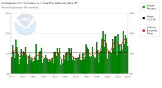
NCEI’s Climate Extremes Index, which covers 1910−2020, offers another way to measure this change. The index shows that one-day rainfall totals in the contiguous United States have increased dramatically since the 1990s. In fact, the United States experienced its wettest 12-month period on record from July 2018 to June 2019. Extremes in 1-day precipitation have been steadily rising in the contiguous United States.
Stronger hurricanes and typhoons
The warming world is also affecting hurricanes and typhoons. As oceans warm and sea levels rise, hurricanes and typhoons are not becoming more frequent, but they are becoming stronger and more destructive—driven by underlying climate change.
- First, rising sea levels provide a higher starting point for a hurricane’s storm surge, enabling it to penetrate farther inland, particularly when a storm makes landfall during high tide.
- Second, hurricanes and typhoons carry more moisture and drop more precipitation because warm air holds more water vapor than cold air.
- Third, these storms are becoming more intense at landfall because of warming oceans. Cooler subsurface water can slow the growth of a hurricane, but this natural braking mechanism is being lost as ocean temperatures increase. In fact, several hurricanes in the past decade have increased in strength prior to landfall as they passed over pockets of warm ocean water.
- Fourth, increasing temperatures are making hurricanes more likely to meander and stall. Hurricanes need wind to move them along, but rising global temperatures are resulting in weaker winds over many populated land areas. Without strong winds, a hurricane’s trajectory changes to a meandering and stalling pattern. Once over land, a slow-moving or stalled storm can produce huge quantities of rain, causing dramatic and devastating flooding, such as that produced by Hurricane Sally in 2020, Hurricane Dorian in 2019, and Hurricane Harvey in 2017.
Looking ahead
Adaptation efforts have established a foothold. As current and future precipitation conditions veer from previous expectations, public and private sectors are presented with challenges, which could bring about new information and tools to deal with more extreme rainfall totals.


.png?itok=ozM9YhtT)
