How the Key Bridge Collapsed in Baltimore: Maps and Photos
On Tuesday, a major bridge in Baltimore collapsed into the water seconds after it was struck by a cargo ship, sending vehicles on the bridge into the river below. The ship lost power and issued a mayday call shortly before it hit the bridge.
The ship, a 948-foot-long cargo vessel called Dali, was about a half hour into its journey toward Colombo, Sri Lanka, when it hit a main pillar of the bridge. All crew members are safe, according to the ship’s owners.
Follow our live coverage.
A mayday call from the ship gave officials enough time to stop traffic at both ends of the bridge. The waters where the bridge collapsed are about 50 feet deep. By Tuesday morning, six construction workers who had been fixing potholes on the bridge remained missing as divers and other emergency workers on boats and helicopters continued to search for them. Two others had been rescued, and one was in the hospital.

Baltimore
Francis Scott
Key Bridge
Patapsco River
Patapsco River
The ship left the Port
of Baltimore around
1 a.m. on Tuesday.
Where impact occurred
Direction of the ship
Francis Scott
Key Bridge
The ship hit the
bridge at 1:28 a.m.
1 mile
200 feet

Baltimore
Patapsco River
The ship left the Port
of Baltimore around
1 a.m. on Tuesday.
Francis Scott
Key Bridge
The ship hit the bridge at 1:28 a.m.
1 mile
Francis Scott
Key Bridge
Patapsco River
Where impact occurred
Direction of the ship
200 feet

Baltimore
The ship left the Port
of Baltimore around
1 a.m. on Tuesday.
Patapsco River
Francis Scott
Key Bridge
The ship hit the bridge at 1:28 a.m.
1 mile
Francis Scott
Key Bridge
Patapsco River
Where impact
occurred
Direction of the ship
200 feet
Source: Spire Global
The New York Times; satellite image by Google Earth
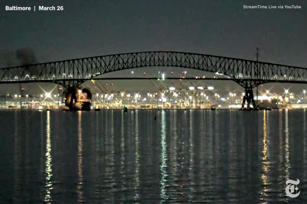
The lights of the ship flickered on and off as it lost power in the minutes before the ship changed bearing and hit the bridge.
1:25 a.m.

1:27 a.m.

1:28 a.m.

1:28 a.m.

1:28 a.m.

1:29 a.m.

Source: StreamTime Live via YouTube
Timestamps are from StreamTime Live video.
The New York Times
The Francis Scott Key Bridge was opened in 1977 and carried more than 12.4 million vehicles last year. The bridge was one of the three major ways to cross the Patapsco River and formed part of Baltimore’s beltway.
The Port of Baltimore is a major trade hub that handled a record amount of foreign cargo last year. It is an especially important destination — the nation’s largest by volume last year — for deliveries of cars and light trucks.


Baltimore
95
Fort
McHenry
Tunnel
895
Baltimore
Harbor
Tunnel
Curtis
Bay
Patapsco
River
Dundalk
695
Ship impact
Francis Scott
Key Bridge
Sparrows
Point
To Chesapeake Bay
2 miles


Baltimore
Fort
McHenry
Tunnel
Locust
Point
95
Baltimore
Harbor
Tunnel
Dundalk
895
Patapsco
River
Ship
impact
Curtis
Bay
Sparrows
Point
Francis Scott
Key Bridge
695
To Chesapeake Bay
2 miles
Sources: Maryland Port Administration, OpenStreetMap, MarineTraffic
Note: Ship positions are as of 2:46 p.m. Eastern time.
The New York Times
Overall, Baltimore was the 17th biggest port in the United States in 2021, ranked by total tons, according to the Bureau of Transportation Statistics. The bridge collapse brought marine traffic there to a standstill, with seven cargo or tanker ships stranded in the harbor as of Tuesday afternoon.
Gov. Wes Moore declared a state of emergency for Maryland and said that his office was in close communication with Pete Buttigieg, the U.S. transportation secretary. The White House issued a statement saying that President Biden had been briefed on the collapse.
Erin Schaff/The New York Times